|
 Met'Map User Guide
Quick chapters browsing :
Before using our web site or any other Internet service provided by Orbifly,
please read carefully our
electronic services End User License Agreement.
Thank you !
FIRST TIME USING MET'MAP
First of all, welcome to Orbifly Met'Map, a free aviation web site provided by the premier European
based FAA flight training organisation.
Met'Map is available via this simple address : www.orbifly.com/metmap
Access to Met'Map is free and provided as is. It requires no specific registration or payment.
Active and former Orbifly students are provided with a username and password providing them with a
customised web portal as well as extra features (Premium Account or Gold Status).
Also, even without being a former Orbifly Student, you can obtain a login and a password and therefore
obtain Orbifly Silver Status. This shall provide you with some extra features such as electronic services
customisation and a specific handle to participate in the Orbiflyers community.
In order to do so, please click on the
"Register"
link located on the top right of the web page.
|
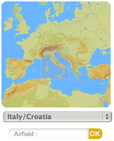
Access to Met'Map alternate views is done through the following clickable tabs :

Once you've selected the view, you may zoom into a specific location by clicking directly on
the airfield you want or by using the provided shortcuts on the left navigation panel.
This can be done in different ways :
- By clicking directly on the mini map and selecting a zone of interest ;
- By selecting a specific map using the drop down menu ;
- By typing the name or the ICAO code of the field you want to view.
If you don't know the ICAO code of the field, just start typing and you
should be provided with a list of airfields.
|
|
New on Met'Map !
You can enter the icao code of any airfield in the World, even if it does not exist on Met'Map !
Our server will try to pinpoint the airfield location. If successfull, you will be provided with
any available information (METAR, TAF, NOTAMs).
You can also add comments about that new airfield, and request its addition on Met'Map.
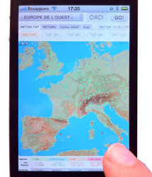
THE "METAR-TAF" VIEW
|
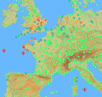
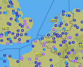
Met'Map provides the pilot with a synthetic view of the meteorological flight category for the
depicted aerodromes based on specific cloud and visibility criteria.
Each airfield will be categorised as VFR,
Marginal VFR, IFR, Low IFR, Very Low IFR based on the latest aviation meterological messages if available
(the analysis is based on the latest aviation meteorological routine reports and the forecasts are based on the
latest TAFs).
Each meteorological flight condition is associated with a specific colour, the details are provided in
the legend below the map.
|
|
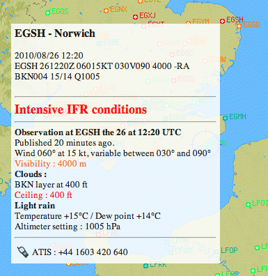
When you hover your mouse about an airfield in the analysis map (METAR), a pop-up should appear over
the map containing the raw text METAR as well as a decoded version in the language you selected in your
preferences.
In this pop-up, the specific weather phenomenon triggering the flight condition classification will
be highlited using the appropriate color.
Wind data is not used to determine the Flight Category but if surface winds are forecast to be in excess
of 20 kts, this information will always be highlighted in red.
A warning shall also be provided if the classification is based on a METAR that is more than 60 minute old.
A report that has not been updated after 2 hours wil be removed from the map and no longer used to determine
the flight category.
|
|
Dangerous weather phenomenons such as Thunderstorms, Fog, Heavy Snow/Rain are highlighted by the
addition of an icon on top of the designated airfield.

Automatic refresh :
Using browser based technologies, the maps should automatically be updated every 10 minutes on most browsers
(Latest Safari, IE, Firefox and Explorer versions).
When you hover your mouse over an airfield, the information is retrieved directly from our online database
therefore the information contained in the pop-up may be more recent than the map itself. If it is the case and
you want an updated version of the map, you only have to reload the page to get the latest version of the map.
Alternatively, you may also wait for the map to update itself.
Information is updated on our servers upon receipt from the appropriate data sources.
TAF Coloring :
You are using Met'Map version 2.0, as a new service included in this version, we have updated the
flight category classification to take Aerodrome Forecast into account. To switch between the analysis
and the outlook maps, use the mouse or keyboard arrows to move your position on the timeline and depict
current analysis or 3,6 9 and 12 hour forecasts :

When using the forecast views, the full text of the TAF is available in the pop-up.
To determine flight category, the most limiting conditions that are forecast at selected time will always be used.
Aerodrome forecasts (TAF) that contain the terms BECMG, TEMPO or PROB are used to determine the forecast
flight conditions for an aerodrome in the following manner :
Where conditions are forecast to improve, the forecast BECMG condition shall be considered to be applicable
as of the end of the BECMG time period but not knowing the rate of change Orbifly elected to categorise the
flight conditions on the basis of the conditions that are expected to occur at then end of the period.
Therefore for these types of messages, the flight conditions should be considered as a trend and not an exact
depiction of the flight conditions at the specific time selected.
Where conditions are forecast to deteriorate, the forecast BECMG condition shall be considered to be applicable
as of the start of the BECMG time period and the message will be categorised accordingly.
Where the forecast TEMPO or PROB condition is worse than the prevailing conditions, this information will be used
to determine flight category for the period, if the conditions are forecast to be better during the period, the
prevailing conditions will be used to determine the flight category.
Selecting an aerodrome :
|
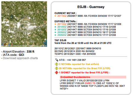
When you pinpoint an airfield, if it is an European one, the map will zoom on the specific aerodrome
and in any case a detailed information box will become visible below the map.
In this box you will find the following information :
- Latest METARs : The current METAR as well as the previous ones in a
3 hour window will be displayed provided a clue about recent weather and Flight Conditions observed at the aerodrome.
- TAF : The latest TAF if the current time is within its validity period.
- Phone Numbers : For on-field MET Office and ATIS (if available).
- NOTAMs : Aerodrome and FIR NOTAMs for the selected aerodrome.
- SIGMETs : Sigmet Information if there is an active SIGMET
in the FIR associated with the aerodrome.
|
|
"NOTAMs" VIEW
The "NOTAMs" view usage is similar to the METAR-TAF one. It is automatically updated every 10 minutes
on most browsers but you can force a refresh by reloading the page.
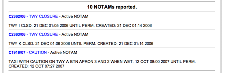
Each airfield is represented by a coloured badge.
Inside the badge, a single digit indicates the number of NOTAMs currently available for the depicted airfield.
If more than 9 NOTAMs are available, the digit will be replaced by a plus symbol (+).
|
The colour of the badge provides a visual clue about the validity period of some NOTAMS for the depicted airfield :
- PURPLE : Caution, there is at least one new NOTAM coming into effect today
for this field ;
- DARK BLUE : Some NOTAMs are still in effect today ;
- LIGHT BLUE : Future NOTAMS, there are published NOTAMS coming into force at a future date.
If you hover your mouse over a badge, a pop-up should appear providing information about the active notams
for an airfield in an abbreviated format if the NOTAM list is long.
|
|
|
The Flight Information Regions (FIR) are depicted on the map using a rectangle coloured label.
The label turns yellow if there are NOTAMs published for the FIR.
By clicking on the FIR label or the aerodrome badge, you will retrieve the full list of published NOTAMs
for the airfield or the selected FIR. If possible, a keyword will be used as a prefix to help your browsing
and NOTAM decoding process.
|
|
CAUTION :
Only International NOTAMs depicted, for a selection of airfields and FIRs.
This implies that NOTAMs that are not internationaly broadcasted will not appear on Met'Map.
Moreover, please note that only European NOTAMs are available. Some NOTAMs may be visible for airfields outside Europe but
this does not mean that no other NOTAMs exist for these airfields.
"Orbiflyers" VIEW
Orbiflyers view includes both two services. First it serves as a social utility between Orbiflyers
helping you to make contact with fellow pilots to exchange tips, ideas about flying in general or other
related or unrelated subjects.
It also includes a "Places to Fly" map that provides first hand knowledge, general tips and other informations
about airfields. Here you can read information about aerodromes, including fuel prices and airport fees.
You can also update existing information, and even create new listings about Met'Map airports that we don't
have any information on yet.
It is easy to use !
This map is only available to registered users (Premium Access or Silver Access) and it works in a
similar way to the previously described maps.
|
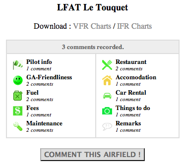
If you hover your mouse over a badge, it will open a pop-up with summary information about the aerodrome
using an icon for each type of service for which a comment is provided. In many cases, a rating is also
provided using a color coding scheme.
The digit inside the aerodrome badge indicates the number of published comments about the aerodrome.
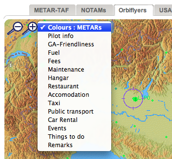
The colour of the badge may have a specific meaning depending on the menu selection.
By default, the badge will use the same colour as the current Flight Conditions at the aerodrome
(as on the METAR map).
|
|
|
You can modify this behaviour by selecting a different option on the scroll-down menu.
If you do so, the colour of the badge will depend on the specific criteria you selected (Landing Fees,
Restaurant, Car rental, Taxis, ...).
The color of the badge will be based on the weighted average of the different ratings assigned to
the selected criteria by participating Orbiflyers. An average restaurant will be coded yellow and a bad
one will be red.
If you select the Events criteria, the color coding will be based on the date of the event.
Gold Status members will also be able keep in touch with other students by checking on wich airfields
they can meet fellow Orbiflyers. This feature is not available to Silver Status Members.
|
|
|
|
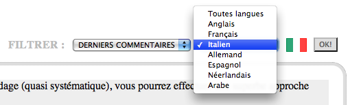
When you select an aerodrome, you can browse through the comments for the selected airfield
filtering them by date or by a specific criteria :
|
|
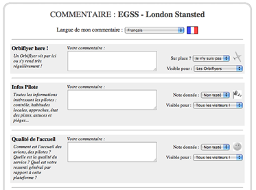
If you want to add a comment, by all means, feel free to do so and click on any aerodrome
to add a comment.
For each criteria you can add:
- A rating : Good, Average, Bad, not tested.
- A full text comment in the language of your choice.
- A filter to restrict access to your comment to specific users.
- A date for an event
Note : All comments made by Silver members will need to be approved by a moderator before publication.
|
|
New on Met'Map !
You can perform a lookup for airfields that are not currently depicted on Met'Map.
The server will query its worldwide aeronautical database and try to pinpoint the requested aerodrome location.
In case of success, if you add a comment the aerodrome, the latter will be included in Met'Map as a permanent addition.
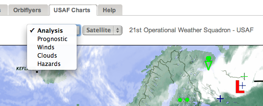
HOW TO USE THE USAF MAP
|
Thanks to the USAF 21st Operational Weather Squadron, a complementary set of charts for the weather-savy Orbiflyer
will give you a broader picture of the weather to come. It is a nice add-on to Met'Map.
Prognostic, Analysis, surface an upper air charts as well as many specific purpose charts are available under this tab.
Thanks to the US Air Force
|
|
|
YOUR MEMBER ACCESS
You can log onto Met'Map with two different kind of membership : Silver or Gold.

|
Free access for all pilots after online subscription.
- access to the Orbiflyers Map
- possibility to write comments about airfields
- possibility to customize Met'Map
- access to new Bêta services being developed
- in the future : login for the mobile version
|
|

|
Private access for Orbiflyers only (Orbifly students and former students).
Just use the same login and password that were delivered to you during your training.
If you lost them, you can retrieve them
here.
- same features as the Silver accounts with some extras
- access to the Orbiflyers Portal with all services (logbook, reminders, Orbitest, videos...)
|
|
Once logged, you can configure your online access : language preferences, default map, connection (temporary
or permanent), etc.
Gold Members can also connect to their online Orbiflyer Portal.
To subscribe or retrieve your access,
follow this link.
|
|
|
ADD THE MET'MAP ICON
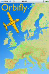
The mobile version of Met'Map 2 is available here :
http://www.orbifly.com/mobile
A light version is also available here (with no map or heavy graphics) :
http://www.orbifly.com/brief
You can add an icon on your iPhone in order to access Met'Map more easily. If your iPhone has the OS 4.1
or higher installed, this will even install a WebApp. Just follow those steps...
|
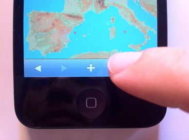
On SAFARI, load your favourite chart then touch the "+" sign located below the chart.
|
|
|
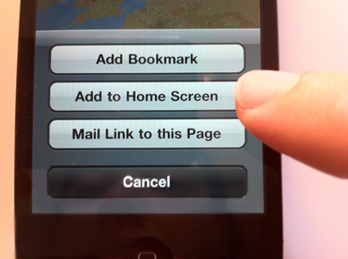
In the pop-up menu, choose the option : "Add to Home Screen".
|
|
|
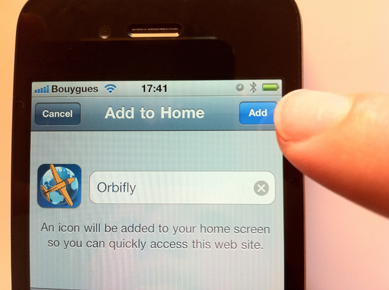
Then touch the "Add" button. You're done, the icon was added on your iPhone !
|
|
|
If the OS of your iPhone is recent (version 4.1 or higher), this icon will open a "WebApp" version of Met'Map.
|
|
|
This WebApp version allows Met'Map
to use the whole screen by removing
the option bar below the map. It also provides you with some more graphical features.
|
|
If you update your iPhone OS and want your Met'Map to upgrade to the WebApp version, don't forget to
delete your Met'Map icon and create it again.
|

|
|
 |